Before starting, review the following:
However, we need to know how to detect that there is a problem with the SRS/CRS. ArcGIS products make this more challenging because they will Project On the Fly. In other orders, if you have geographic data with a correct SRS/CRS and you have your map set to display in UTM, ArcGIS will project your geographic data to be in UTM.
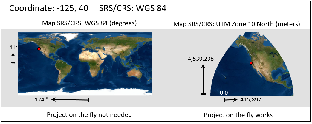
The image below shows data that is in geographic (longitude, latitude) and has an associated SRS/CRS of WGS 84 (unprojected or geographic). The coordinates show that the data is in degrees and you can check the SRS/CRS by loading the data into ArcGIS (or another GIS application) and checking the data's properties. For a shapefile, the SRS/CRS will be in the file with the "prj" extension. What is critical is that the SRS/CRS that is associated with the data matches the data.
One approach to check if the data is correct is to load the data into a map that is set to display in geographic (e.g. WGS 84) and then change the display to a projected system. If the data appears in the correct location in both maps, then the data probably has the proper SRS/CRS. Note that the datum could still be incorrect as the difference between NAD 27 and WGS 84 is typically less than 100 meters which will not appear in the images below. YOu'll want to zoom in to make sure the data is appearing in the correct location.
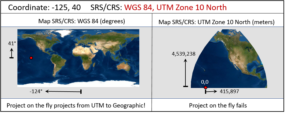
If the same data does not have an SRS/CRS, it will appear to be in the correct location if the map is set to display data in the SRS/CRS that matches the data. If we change the SRS/CRS for the map display, then we will see that the data does not have the correct SRS/CRS. This occurs because the GIS application does not know what the SRS/CRS is so it cannot project the data correctly. Instead it assumes the data matches the current display SRS/CRS. In the example below, our coordinates, which are in degrees, are interpreted as being in meters in a UTM projection. Thus, they end up 40 meters above the equator and far to the west of their actual location.

The way to fix the data above is to: Define the SRS/CRS to WGS 84
If the data has an incorrect SRS/CRS it will typically appear in the wrong location all the time. In the example below we have geographic data that has been mistakenly defined to be UTM data. If we set the map to WGS 84, then the GIS application will project the data from UTM to decimal degrees and the data will appear on the equator near the origin of our UTM zone.
The way to fix the data above is to: Define the SRS/CRS to WGS 84

If the SRS/CRS for a projected data set is unknown, the data will appear correctly when the map's SRS/CRS matches the SRS/CRS that should be associated with the data. However, when displayed in WGS 84, the data appears in never-never land. Take a look at the coordinates to see what is happening. The GIS application is trying to display the data as geographic because it does not have an SRS/CRS that tells it to do anything else. Then, we end up with latitude and longitude values that are in the hundreds to millions of units. Since the valid range for longitude values are -180 to 180 and -90 to 90 to latitude, these values are no where near where the rest of the data is being displayed. Note that some GIS applications will draw this data and some will just give up (ArcGIS Pro appears to give up).
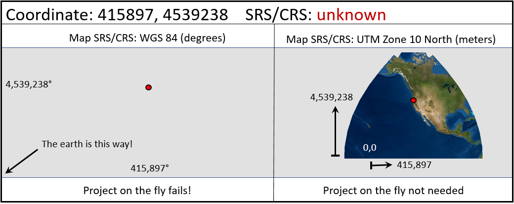
The way to fix the data above is to: Define the SRS/CRS to WGS 84, UTM Zone 10 North
If the data has an incorrect SRS/CRS, it will typically appear in the wrong location on the earth. In the case below we have UTM data that is defined as geographic (WGS 84). When the map is set to WGS 84, the data appears somewhere way off in the north east, far from the earth. When the map is set to display in UTM, the computer will actually take the geographic coordinates and project them to UTM. Typically this will just fail because the coordinates are way too large to be geographic coordinates.
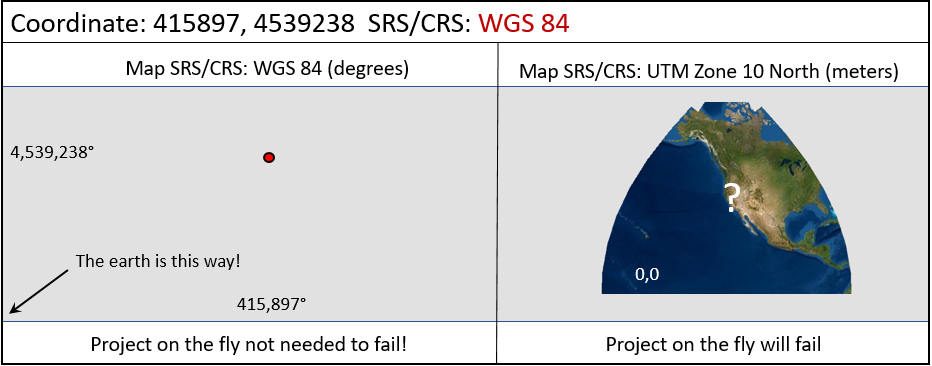
The way to fix the data above is to: Define the SRS/CRS to WGS 84, UTM Zone 10 North
The real key to success is knowing when to Define and when to Project. When we Define the SRS/CRS, the SRS/CRS is changed and the data is not. So we want to use Define when the SRS/CRS is unknown or incorrect.
The diagram below shows that we have geographic coordinates on the left and an unknown SRS/CRS on the right.
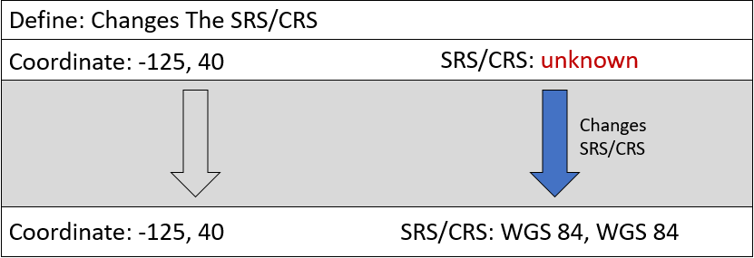
When the SRS/CRS is Unknown: Define it to the SRS/CRS that matches the data
The diagram below shows that we have an SRS/CRS that does not match our data.
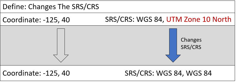
When the SRS/CRS is Incorrect: Define it to the SRS/CRS that matches the data
Only after the SRS/CRS is correctly Defined should we Project it to the SRS/CRS we want to work in.
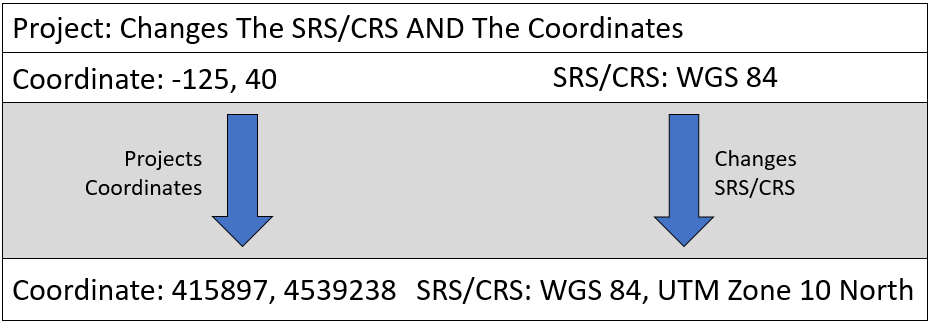
After the data has a correct SRS/CRS: Project it to the SRS/CRS you want to use for research
© Copyright 2018 HSU - All rights reserved.